AN EXPLANATION OF TROPICAL RAINFALL: BETWEEN 1492 AND 2020 Paperback $25.00
Please confirm your country of DELIVER TO
The following are the images found inside this book:
A dhow sailing in the Indian Ocean
Amazon forest viewed from the sky (nasa)
Atlantic Slave Trade ship (fineartamerica)
Canoes fishing on a lake (kuleacanoes)
Charles Darwin expeditions (seasky)
Christopher Columbus voyages
Climatological precipitation stations (researchgate)
Climatological Stations in the world
Convergent air mass circulation (kejian1.cmatc.cn)
Dhows and Slaves Routes (KAPPA MAP GROUP)
El Niño and La Niña Air Masses
Freshwater Biomes (freshwaterinfo.weebly.com)
Inter Continental Air Routes of the 1930s
ITCZ air mass borders
James Cook expeditions (Alan John Villiers)
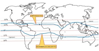
January and July ITCZ (researchgate.net)
Lakes of the World (freshwaterinfo)
Magellan Pacific Ocean route (gohighbrow)
Magellan route and chronology (Valerie I.J. Flint)
Map of the Amazon forest (sciencedirect)
Map of the Congo Rainforest (mongabay)
Maritime Continent (en.wikipedia.org)
Monsoon activity (Roger Smith, Date 15 Jun 2015)
Mosquito prevalence (elifesciences.org)
Orographic (or relief) rainfall (britannica.com)
Persons per square kilometer
RADIOSONDES distribution April 1984 (curry.eas.gatech.edu)
Rain- fed agriculture (agupubs.onlinelibrary.wiley.com)
Soaring High (shutterstock)
Southeast Asian rain forest (en.wikipedia.org)
Stable air mass viewed from the sky (peter2000)
Tephigram of stable air mass (mcgill)
Tephigram of unstable air mass (mcgill)
The Findlater jet
The ITCZ viewed from the sky (steampowered)
Tropical Rainfall Air Masses
Tropical rainfall borders
Tropical Rainfall Rivers (researchgate)
Tropical storm names (stroms_cyclones)
Vasco da Gama voyage of 1498 (Maninder Dabas)
Water Vapor Concentrations (earthobservatory)
Wettest places in the world


.jpg)
.jpg)
.jpg)
.jpg)

.jpg)

.jpg)
.jpg)

.jpg)


.jpg)
.jpg)
.jpg)
.jpg)
.jpg)
.jpg)
.jpg)
.jpg)
.jpg)
.jpg)
%20rainfall%20(britannica.com).jpg)

.jpg)
.jpg)
.jpg)
.jpg)
.jpg)
.jpg)
.jpg)

.jpg)


.jpg)
.jpg)
.jpg)
.jpg)

No comments:
Post a Comment